 |
| |
|
|
|
|
|
|
 |
|
| Joint Research Centre Innovations for Tsunami Risk Management |
|
More than 700 million people live in low-lying coastal areas and Small Island Developing States, exposed to extreme sea-level events including tsunamis. Globally, in the past 100 years, 143 tsunamis have been recorded in the NOAA database of natural hazards, causing more than 300.000 victims.
5 November was designated in 2015 as World Tsunami Awareness Day (WTAD) by the UN General Assembly. Since then, every year the global community involved in tsunami risk management mobilize to raise awareness about this threat and about the importance of having a governance to handle it. Each year the WTAD campaign is inspired to one of the targets of the Sendai Framework for Disaster Risk Reduction 2015-2030 (Sendai Framework), the major agreement which provides Member States with concrete actions to protect development gains from the risk of disaster.
5 November 2020 celebrates how people around the world, at all levels -from international organizations to national governments, local communities, and individual citizens- are reducing their exposure to tsunamis, in a collective, cooperative effort.
This special issue newsletter from the Disaster Risk Management Knowledge Centre shows recent projects of the European Commission that directly or indirectly contribute to better tsunami risk management globally, through providing innovative solutions for handling such risk in the exposed coastlines.
|
|
|
|
|
| Content |
|
| The tsunami of last week in the Mediterranean region |
|
The tsunami triggered by the 7.0 magnitude earthquake in the coastal province of Izmir on 30 October 2020 was recorded by three of the sea level stations designed and installed by JRC in the region: two in Kos and one Plomari (Greece, see figure below). Despite the few centimeters measured at shore, quite important inundations took place
(https://twitter.com/ragipsoylu/status/1322154989003878400?s=20).
Thanks to the long-lasting close collaboration with the Greek and Turkish institutes involved in tsunami risk management, further strengthened by the implementation of the Tsunami Last Mile projects in
|
the two countries, JRC is participating to the ongoing tsunami impact assessment efforts. Given the ban on international travels due to Covid-19, JRC is providing remote support for the scientists in the field.
Moreover, 3 hours after the earthquake, the Copernicus rapid mapping service was activated to detect from satellite data the impact of both, the earthquake and the tsunami. The first maps from the European mapping service are available at this link: https://emergency.copernicus.eu/mapping/list-of-components/EMSR476.
|
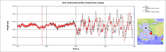
Figure 1: tsunami wave recorded by the two IDSL (Inexpensive Device for Sea Level Monitoring) stations in Kos (Greece)
|
|
|
|
|
|
| The Commission contribution to the Tsunami Early Warning system of Indonesia |
|
The collaboration between the JRC, DG ECHO and the Ministry of Maritime and Fisheries of Indonesia initiated in 2019 when the JRC provided the country with 8 IDSL devices to quickly implement a new Tsunami Warning System in the aftermath of the Anuk Krakatau volcano explosion on 22 Dec 2018. The event triggered a severe Tsunami, killing more than 400 people in the Sunda Strait.
Since then, the collaboration between
|
the Commission and Indonesia never stopped and the latter recently announced the acquisition of 100 JRC-designed IDSL (Inexpensive Device for Sea Level Monitoring) units in the near future and a more ambitious implementation of an additional 530 units over the coming years, to enhance its Tsunami Early Warning system.
|
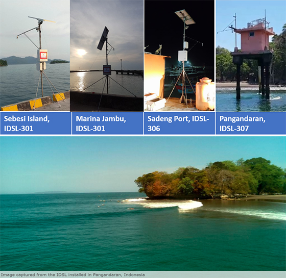
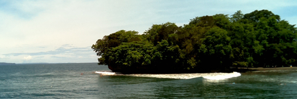
Figure 2: TOP - Installations of 2019; BOTTOM: image captured from the IDSL installed in Pangandaran, Indonesia
|
|
|
|
|
|
| Tsunami detection offshore: a scientific experiment to fill a data gap in the Mediterranean |
|
The regional tsunami warning system in the Mediterranean (ICG/NEAMTWS) cannot count, nowadays, on off-shore sea level measurements: as of today, there are no deep water buoys in the region, to detect the passage of a tsunami wave before it reaches the coast.
Therefore, JRC started a scientific research, in collaboration the Italian ‘Istituto Superiore per la Protezione e la Ricerca Ambientale', for the instrumentation of an oceanographic buoy with advanced technology that allows the centimetric estimation of the sea level, using the differential GPS technique. The advantage is the possibility to position the buoy at
|
10-15 km from the coast, allowing to detect a tsunami offshore, thus gaining time for the alert dissemination.
This technology is not new as it is in use in Japan since several years, but it is the first time that is adopted in the Mediterranean Sea. In addition, using modern technologies at low cost, JRC was able to considerably reduce the costs respect to the traditional models. After the current testing period in the Tirrenian sea, if the results and the data acquired are satisfactory, the buoy will be repositioned in southern areas, e.g. the Ionian Sea or Sicily Channel.
|
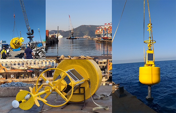
Figure 3: GPS buoy installation operations in La Spezia gulf (Italy, July 2019).
|
|
|
|
|
|
| IDSL: a JRC designed low cost solution to thicken the intenrational sea level monitoring network |
|
35 devices in the Euro-Mediterranean region; 7 devices in Indonesia, where the installation of another 100 is foreseen in the very next future; 5 seconds sampling interval and 1 second latency time; cost of 2-3 kEuros compared to the 30-40 kEuros of traditional systems: these are the figures of the IDSL (Inexpensive Device for Sea Level Monitoring) network, set up by the European Commission to contribute to the international efforts for tsunami early
|
warning.
Network in Euro-Med region: https://webcritech.jrc.ec.europa.eu/TAD_server/Home?group=IDSL
Network in Indonesia: https://webcritech.jrc.ec.europa.eu/TAD_server/Home?group=Indonesia
|
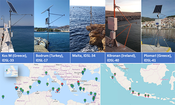
Figure 4: TOP - installations in the Euro-Med area in 2019; BOTTOM - location of all the network ‘devices
|
|
|
|
|
|
| How to warn on time the citizens on the coastline? A pilot project to investigate solutions and raise awareness |
|
The Joint Research Centre develops innovative technological solutions for disaster risk management, including newly designed sensors and alerting devices for tsunami risk. The Directorate General for European Civil Protection and Humanitarian Aid Operations (DG ECHO) is funding the test of their effectiveness and interoperability since 2018, through the Tsunami Last Mile projects. Greece and Turkey experimented it first (2018/2019); the current test is ongoing in Malta and Indonesia (2020/2021).
|
The objective is to finetune the system, raise local awareness and build capacity to make it possible to save lives also in case of tsunami events with very short warning times.
Video by UNDRR on the first project implementation: https://www.youtube.com/watch?v=I6_ODnUQiEA&list=PLBDwPnveHho_FW0tju0-mCD53cJF2FrGf&index=4.
|
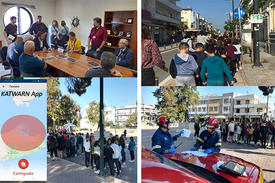
Figure 5: images from Koswave exercise, held in Kos (Greece) on 19 Nov 2020, as a final test of the local implementation of the Tsunami Last Mile suite of devices.
|
|
|
|
|
|
| RIO - Remote InterOperability platform for a network of interoperable devices |
|
The experience of several years and the multiple technical innovations developed led the Joint Research Centre to create a reliable and resilient Operating System (OS) to manage all the functionalities of remotely deployed devices, often of different design and purpose (e.g. seismic sensors, sea-level stations, digital warning panels).
RIO, the Remote InterOperability platform, is an extensible multipurpose platform to build a
|
network of interoperable devices. Through it, any local monitoring/alerting network can easily ingest, process and distribute information from larger ones, provided that they are shared in CAP (Common Alerting Protocol) format. This is what is needed to link regional, national, local systems for timely and effective warning in case of tsunamis.
|
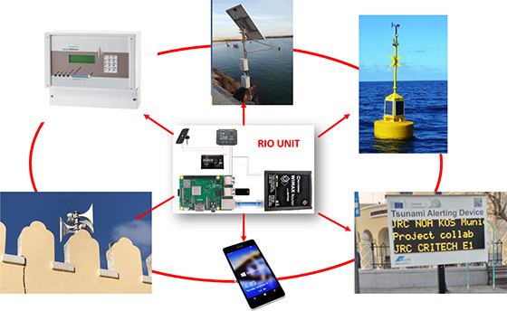
Figure 6: RIO, the Remote InterOperability platform to easily connect all sensors together.
|
|
|
|
|
|
| Tsunami preparedness : risk assessment in Andalusian West Coast, Spain |
|
The Spanish General Directorate of Civil Protection and Emergencies (CENEM) triggered the Copernicus Emergency Management Service (CEMS) Risk and Recovery Mapping in July 2020 to develop tsunami risk analysis in the urban environments along 300 km of the Andalusian West Coast, equal to an area of about 6,780 km2.
This activation supports civil protection preparedness activities in the area. The recently completed results include information on tsunami hazard, exposure, and vulnerability of the buildings.
|
Although Spain has a recently approved civil protection national plan against tsunami risk and a tsunami warning centre managed by the Instituto Geográfico Nacional of Spain, still lacks regional and local plans which have to be developed from now on. This Copernicus activation is a significant step forward towards this goal in the Spanish southern region, the most affected by the tsunami risk in Spain.
Due to the sensitive nature of the results, the products have only been shared with the authorized user. The publishable cartography, along with a summary description of this activation, can be found on our Mapping portal here.
|
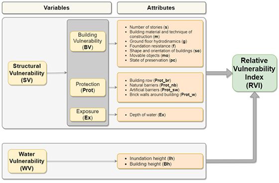
Fig 7. Workflow to determine Building Relative Vulnerability Index. (Copernicus EMS © 2020 EU)
|
|
|
|
|
|